Introduction
This page was researched by Bill Cormack and passed to the heritage group. It looks at the history of Ordnance Survey Bench Marks in relation to the village of Stonehouse in South Lanarkshire.
Historical Information (sourced ordnance survey)
The Ordnance Survey has its roots in military strategy: Mapping the Scottish Highlands following rebellion in 1745. It was an innovative young engineer called William Roy who was tasked with the initial small-scale military survey of Scotland.
Starting in 1747, it took eight years to complete what was known as the Great Map at a scale of 1:36 000 (1.75 inches to a mile). Roads, hills, rivers, types of land cover and settlements were recorded. William Roy described it as rather a ‘magnificent military sketch than a very accurate map of the country’.
A surveyor called Thomas Fredrick Colby introduced height to Ordnance Survey maps by commissioning a national geodetic levelling survey in relation to mean sea level in Liverpool measured using a tide gauge.
The original Liverpool levelling was started in 1840 using a bench mark on the tower of St John’s Church, Old Haymarket. The surveyor’s description was bolt on the south face of the tower 4.98ft above surface (p2/142) with a height of 57.0000ft above sea level.
In 1844 the datum was changed to the tidal pole in Liverpool Victoria Dock and tidal observations took place over a nine day period. The first primary levelling across England, Wales and Scotland, was carried out 1840-60.
The primary levelling of the whole Scotland was completed by 1860 (finishing at Ballinluig, by Pitlochry). This formed a suitable base for more detailed secondary levelling, to fill in a more detailed pattern of spot heights, bench marks and contours.
Due to the imperfections with the levelling, it was decided to undertake a second geodetic levelling (1912 to 1921). It was at this time that mean sea level was fixed at Newlyn in Cornwall. Fixed points throughout the country were established known as fundamental bench marks (FBMs).
Lanarkshire surveys 1856-1859, 1892-97 and 1908-1911
One of the earliest ordnance survey maps of Stonehouse was produced in 1859.
The ordnance survey maps show a variety of detailed information OBMS being one of them.
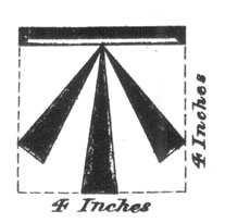
The symbol that is recorded on Ordnance Survey maps indicating bench marks was approved after 1854, they usually appear as an incised horizontal bar with a broad arrow immediately below, the height of the bar accurately determined by spirit levelling. All ordnance survey maps of scale show the symbol as shown below .
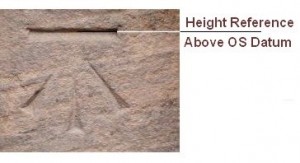
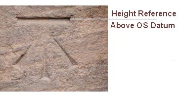
These obscure marks are like secret symbols carved on building and bridges all-round mainland Great Britain . Hidden in plain sight, we walk past them every day without realising what they are and their purpose. They are usually cut / carved into sandstone and take the form of a horizontal line with an arrow pointing up from below. These marks were cut by Ordnance Survey levelling staff to provide a network of points at which height has been precisely measured (to the centre of the horizontal line) above sea level an example of which is detailed below.
It was policy to maintain about 5 bench marks per 1Km square in rural areas, about 30 to 40 in urban areas, and there was a policy to check and renew marks to compensate for losses due to building and road works.
There used to be about half a million bench marks in Great Britain but they are not needed any more due to GPS mapping and about half have now disappeared.
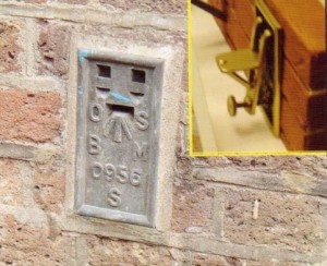
There are other types of bench marks for example a bronze plaque let into the wall on which an arrow records the height.
The name bench mark derives from the angle iron which is fitted into the horizontal cut to give a ‘bench’ or support for a levelling staff. (See Photograph shown to the left). Unfortunately the village of Stonehouse has none of these types of bench marks.
Ordnance Datum (OD)
The OD is the point of reference to which all bench marks are referred, and is the mean level of the sea as recorded over many years at the lowest point in mainland Great Britain, at Newlyn Harbour in Cornwall.
The value of the OD is 0.000m and all ground levels in Great Britain are related to this value, for example if the level of the ground at the entrance of Hill Road from Argyll Street is 145.40 you are 145 metres and 40 millimetres ( 477.05 feet) above the mean sea level at Newlyn.
Stonehouse Ordance Survey Bench Marks
Stonehouse has 21 OBMs some have disappeared and new ones have replaced them others have remained in their position for over 160 years.
Although the ordanance survey maps over the different decades indicate there are 21 Bench Marks(BM) in actual fact there are only 9 BMs remaining that can be seen. It could be argued that Bench marks 1 and 21 in the following table are not within the boundaries of Stonehouse.
The following table shows their locations.
| NUmber | Location | Height in Feet | Height in metres | Additional Information |
|---|---|---|---|---|
| 1 | Road to Sandford Small Bridge | 492.71 | 150.27 | Mark Still visible, one of the original BM from 1859 |
| 2 | Strathaven Road Embankment Mile Stone | 519.8 | 158.54 | Lost through erosion |
| 3 | Manse Rd Small Bridge | 478.96 | 145.98 | mark still visible |
| 4 | Strathaven Rd Stonehouse Hospital External Wall | 525.55 | 160.29 | Mark not visible due to erosion or demolition |
| 5 | Tofts Farm | 512.7 | 156.37 | Mark no visible, one of the original BM from 1859 |
| 6 | Strathaven Rd Railway Bridge | 498.98 | 152.9 | Mark still visible |
| 7 | Sidehead Rd Railway Bridge | 497.73 | 151.7 | Mark still visible |
| 8 | Strathaven Road Tinto View Domestic Property Formerly known as the West Bar Toll House | 490.3 | 149.54 | Mark Still visible, one of the original BM from 1859 |
| 9 | Townhead Primary School | |||
| 10 | Townhead St Domestic Property | 477.08 | 145.17 | Mark Still visible Know as Taits Corner |
| 11 | Vicars Road Railway Bridge | 478.96 | 145.98 | Removed for Bypass |
| 12 | "New Street K. M. Greener Solicitors" | 473.17 | 144.23 | Mark Still visible, previously old ship inn |
| 13 | Watstone Rd Small Bridge | 405.49 | 123.67 | Original bridge Collapsed due to flooding |
| 14 | Watstone Farm House | 474.73 | 144.79 | Demolished due to fire |
| 15 | New St Domestic Property | 473.29 | 144.35 | Mark not visible |
| 16 | Lockhart St Meadowside Cottage Formerly known as the East Bar Toll | 455.12 | 138.81 | Mark Still visible, one of the original BM from 1859 |
| 17 | Candermill Rd Embankment RHS | 418.19 | 127.55 | Lost through erosion |
| 185 | Lawrie St Railway Bridge | 469.7 | 143.16 | Removed for Bypass |
| 19 | Millheugh Rd Embankment LHS | 403.4 | 123.03 | Lost through erosion of embankment |
| 20 | Linthaugh Bridge | 352.4 | 107.48 | Mark not visible possibly lost during renovation works caused by movement |
| 21 | Cander Bridge | 418.58 | 127.66 | mark still visible |
The following galley provides pictures of some of the above locations.


